Map Work
One of the many hats I wear for TAPPS is that of official drone pilot. We have a Mavic 2 Zoom (because of it’s zoom lens). I’ve flown about 1,000 minutes with that drone on 104 flights as of today. The majority of that is actually outside of our events. I shoot a lot of video that gets used in various productions, but a good chunk of my drone work is for planning and wayfinding. This gallery contains some of that work in it’s beginning, middle, and end stages.
When an area is too big to capture in one frame (without a waver from the FAA to fly higher) I make composites. I’ll fly in a grid pattern over a site at around 390ft, then stitch the images together in Lightroom or Photoshop. These are never perfect. The larger the area the more intervention is needed in post. You will see errors and patches below. (I am nearly always on a deadline when I make these, so they are never as finished as I want them to be.)
Sure, you could use google maps, but we don’t own those. Plus, they are often out of date or too low-resolution for our purposes.
Round Rock Multipurpose Complex, Round Rock, Texas.


Pioneer Park Tennis Area, Round Rock, Texas. Composite of 14 images.


Waco Regional Tennis Center, Waco, Texas. Composite of 105 images. The first composite map I did for TAPPS was made for us to number and assign tennis courts, maybe a year before this one was made.


Waco ISD Athletic Complex, Waco, Texas. Composite of 70 images. We also hold events at the golf course just south of here. One day I will make a large composite of both sites.


Battle Lake Golf Course, McLennan County, Texas. Composite of 8 images. This composite was made when considering this site for some of our events.


Waco Convention Center, Waco, Texas. Site of many district meetings along with art and academic competitions. Composite of 27 images. I need to come on a quiet Sunday and get a wider area.


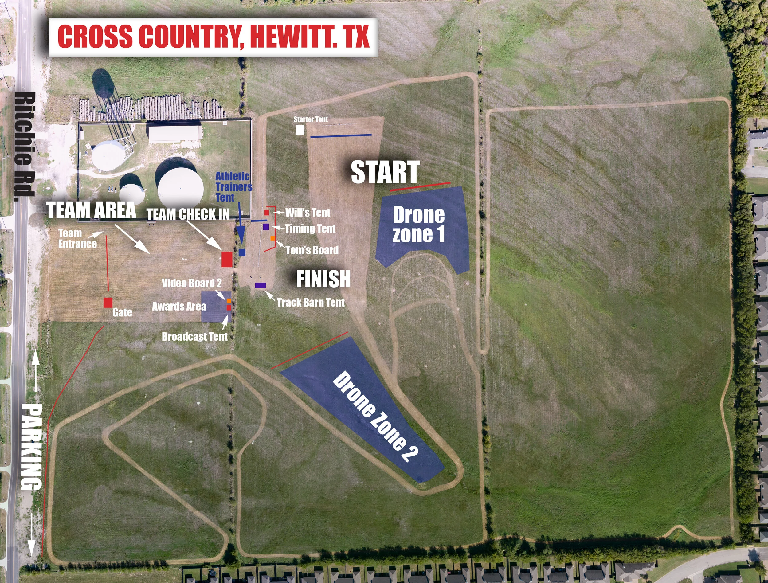
Hay field in Hewitt, Texas. Site of a cross country state meet. Composite of multiple composites. Originally 171 images. This field will eventually be an elementary school. In the age of the coronavirus it’s being used for cross country meets. The course was mowed a few days before I flew. The site is so large that it took 40 minutes and two batteries to photograph it completely. The overlap of the two flights was one reason for the trouble I had making this composite. But I also had to downrez all of the images and try again because scratch disk kept filling up. I haven’t decided if DJI’s lens profile helps or hurts me in these larger composites.